Jenish Patel
Hello
My name is Jenish Patel
Dedicated GIS professional with hands-on experience in geoscience & GIS technologies at Wayfinder Corp. Equipped with a strong academic background in Geographic Information Systems and Civil Engineering. Proficient in GIS software, spatial analysis, data visualization, and project management. Committed to leveraging spatial data to solve real-world problems and enhance operational efficiencies. Adept at collaborating with multidisciplinary teams and delivering high-quality results.


previous education
At Southern Alberta Institute of Technology, I'm studying a Bachelor of Applied Technology in Geographic Information Systems. I find it to be pretty intriguing, and I believe I might succeed in the field of geographic information systems given my background and passion in civil engineering.

Goals
Leveraging my background in civil engineering and expertise in Geographic Information Systems (GIS), my strong future goals involve advancing in GIS to contribute to innovative solutions for sustainable urban development. With skills acquired in my Bachelor of Applied Technology in Geographic Information Systems at the Southern Alberta Institute of Technology, I aim to lead GIS projects addressing urban planning challenges, focusing on the development of cutting-edge web mapping applications.
My ultimate goal is to integrate GIS technologies into urban development, utilizing spatial analysis and data visualization to enhance efficiency and sustainability. I aspire to be a leader in GIS innovation, combining civil engineering knowledge with GIS proficiency to make a meaningful impact on urban landscapes.
Technical Skills (Software)
🗺️
-
GIS & Mapping Software:
ArcGIS Pro, ArcGIS Online, ArcGIS Enterprise, Global Mapper, QGIS, ArcMap -
Web & Mobile GIS:
Experience Builder, ArcGIS Dashboard, StoryMap, Field Maps, Survey123, Drone2Map, QuickCapture, GPS -
Automation & Programming:
Python, ArcPy, FME, ArcGIS Notebooks, ModelBuilder -
Database & Data Management:
PostgreSQL, SQL, Metadata Management, Database Design, Microsoft Access -
Remote Sensing & 3D Analysis:
LiDAR, Polycam, UAV, Pix4D, NDVI, Terrain Modeling, Image Classification -
Engineering & Drafting:
AutoCAD (2D/3D), Surveying, Site Inspection, Construction Monitoring -
Project & Office Tools:
Microsoft Excel (Data Analysis), MS Project, PowerPoint, Word
📱
🤖
🗃️
🌐
🏗️
📊
Soft Skills
-
Adaptability:
Successfully transitioned from Civil Engineering to GIS, quickly adapting to new technologies and workflows. -
Multitasking & Time Management:
Balanced academic and freelance GIS projects, and previously managed store operations and sales strategies. -
Attention to Detail:
Ensured high-quality deliverables in engineering and GIS, reducing errors and improving project outcomes. -
Communication & Teamwork:
Strong written and verbal communication; presented GIS insights in collaborative, cross-functional teams. -
Organization:
Monitored project progress, maintained version control, and handled GIS data across multiple platforms.
🔄
⏱️
🔍
🗣️
🗂️
Portable Skills
🧭
📅
🛠️
🤝
🌍
-
Spatial & Data Analysis:
Overlay, proximity, and network analysis; statistical interpretation; 3D GIS modeling -
Project Management:
Scheduling, stakeholder coordination, field logistics, and reporting with measurable impact -
Problem Solving:
Led innovative GIS-based solutions for planning, routing, and environmental studies (e.g., school capacity, water wells) -
Stakeholder Engagement:
Presented complex findings to non-technical audiences, integrated feedback into iterative project cycles -
Interdisciplinary Collaboration:
Worked across geology, environmental science, and civil engineering teams, ensuring GIS support aligned with technical objectives
Work


Calgary Zoo Migration Project
(GIS Web Mapping Application for the Calgary Zoo)

Network Analysis & Routing
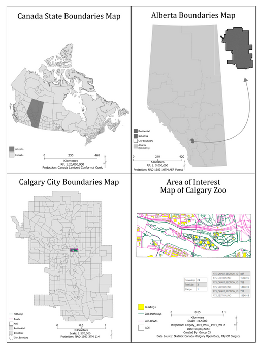
First video introduces the foundational phase of our Calgary Zoo GIS project, showcasing the creation of network datasets for routing. It demonstrates how paths were digitized, optimized, and analyzed to improve navigation for zoo visitors using GIS tools.
3D Statues with Polycam
Here we explore how Polycam was used to capture real-world statues in 3D. These high-fidelity models were integrated into the web map to offer visitors a more immersive and visually engaging experience of key exhibits.
Python Scripting
This segment highlights how Python scripts were used to automate data validation, processing, and integration tasks. Scripting streamlined workflows, ensured consistency, and enhanced data management across the platform.


Building the Zoo in 3D
This video presents the detailed 3D layer development — including roads, buildings, trees, benches, and other features. It illustrates how these elements were styled and placed to create a realistic digital twin of the zoo environment.
Final Product: 2D & 3D Web Mapping Application
This video demonstrates the final interactive web mapping application. Built using ArcGIS Experience Builder and Web AppBuilder, it includes both 2D and 3D environments, enabling users to explore the zoo map, search animal exhibits, and navigate seamlessly.
Automated GIS Workflow for Pipeline Route Analysis
Automated Spatial Analysis Pipeline: Developed a comprehensive ArcPy script to automate DEM processing, Euclidean distance, reclassification, weighted overlay, and cost path modeling for optimal pipeline routing in Cypress Hills, Alberta.
Dynamic Map Creation & Export: Used ArcGIS Pro’s arcpy.mp module to generate maps and export final layouts with dynamic elements (legend, text, and scale), delivering a complete, automated geospatial reporting workflow.

Designed a thematic map showing the distribution of Black individuals in California (2014) using Natural Breaks classification and a NAD 1983 California (Teale) Albers projection at a 1:4,000,000 scale.
Produced a professional map layout with clear symbology, 0.5-inch margins, and letter-sized formatting, highlighting Solano, Alameda, and Sacramento as regions with the highest Black population percentages.
Cartography and Geovisualization
Processed demographic data to calculate population percentages and created a bar chart visualizing the top 7 regions by population.

ModelBuilder
Academic GIS Project
Built automated GIS workflows using ModelBuilder in ArcGIS Pro to streamline spatial analysis tasks.
Connected tools and data to create dynamic, multi-step geoprocessing models.
Configured model parameters for flexibility and ran models to generate visual outputs.

Image Classification
Academic GIS Project
Performed supervised landcover classification using multispectral satellite imagery with Maximum Likelihood and Support Vector Machine (SVM) algorithms to support ecological inventory planning for the Ledum Property Trust near Waiparous, Alberta.
Achieved high classification accuracy (up to 97%) by preparing quality training/testing datasets, applying stratified sampling, and evaluating results through confusion matrices and Kappa statistics for both instructor-provided and online imagery.
Calculated landcover area coverage for five classes (Developed, Barren Ground, Tree/Shrub, Grassland, Water) using 3x3 m resolution imagery and delivered visual layouts and recommendations for improved sampling strategy accuracy.

Georeferencing

Academic GIS Project

Geocoding & Network Analysis
Academic GIS Project
-
Designed and implemented a full geocoding and network analysis workflow using ArcGIS Pro, including the creation of a custom locator and a network dataset using CALGIS_TRANSNET_CENTERLINE.shp.
-
Performed service area and closest facility analysis for fire and police incidents using Fire_Stations.dbf, Police_Service.dbf, and Excel geocoding tables, producing accurate emergency coverage zones.


Geoscience and GIS Technologist
-
Improved data accuracy by 15% using ArcGIS Pro, LiDAR, GPS, and Survey123
-
Identified sand deposits to support profitable, long-term planning
-
Analyzed water well and drill data for sustainable mining operations
-
Created 3D sand models and performed LiDAR terrain analysis
-
Increased operational efficiency by 20% and drill targeting accuracy by 80%
Glenevis, AB
Education
January 2023 to September2024
Bachelor of Applied Technology Geographic Information Systems
Southern Alberta Institute of Technology (SAIT)
A computer system that analyses and presents spatially referenced data is known as a Geographic Information System (GIS). It makes use of information associated with a certain place.
July 2016 to March 2020
Bachelor in Civil Engineering
Sigma Institute of Engineering (Gujarat Technology University)
The design, construction, and maintenance of the built environment, including public works like roads, bridges, canals, dams, airports, sewage systems, pipelines, building structural elements, and railways, is the focus of the professional engineering discipline known as civil engineering.
June 2012 to May 2016
Diploma in Civil Engineering
H. B. Patel Institute of Diploma Engineering & Technology(Gujarat Technology University)
Applying physical and scientific concepts to the design, development, and maintenance of both the artificially produced environment as well as the naturally occurring built environment is known as civil engineering. This comprises physical structures including power plants, trains, highways, sewage systems, canals, dams, buildings, bridges, airports, and more.
About BGIS
A geographic information system (GIS) is a computer programme that collects, stores, verifies, and presents information about locations on the surface of the Earth. GIS may assist people and organisations in better understanding geographical patterns and relationships by connecting seemingly unconnected data.
Why I enrolled in the program
Maps have been intriguing and effective sources of knowledge for countless years. GIS combines the greatest aspects of technology and visualisation. I like making GIS maps because it allows me to work more correctly and professionally, which is why I decided to pursue a career in GIS.
GIS is a fun, innovative, and fascinating technology that combines well with many of the other ones I'm interested in, including video, web design, and mobile apps.


Esri User Conference
Participated in ArcGIS training, focusing on integrating ArcGIS with enterprise systems like Power BI, SharePoint, AWS, and Salesforce for streamlined workflows and improved geospatial analysis.
Explored ArcGIS tools such as StoryMaps, FieldMaps, and QuickCapture, along with insights into ArcGIS Online and Enterprise implementation for secure, scalable solutions.

-
Safe Software: FME Form Basic, Integrate Spatial Data FME Form Advanced
-
Pilot Certificate:
Small Remotely Piloted Aircraft (VLOS)
Basic operation
PC2510870851 -
LinkedIn Learning: Learning ArcGIS Python Scripting
-
Esri Training:
-
GIS Automation & Scripting: Python for Everyone
-
3D & LiDAR Analysis: Introduction to 3D Data, Managing LiDAR & Terrain Datasets, Extracting Raster Surfaces from LiDAR
-
Spatial & Network Analysis: Mapping Clusters, Hot Spot Analysis, ArcGIS Roads & Highways
-
Web & Field Mapping: ArcGIS Indoors for AutoCAD, Survey123, ArcGIS for Excel, Field Data Collection Using ArcGIS
-
Demonstrated expertise in GIS automation, spatial analysis, LiDAR processing, and field data collection.


